La Chapelle-Baloue
| La Chapelle-Baloue | ||
|---|---|---|
| ||
| Staat | Frankreich | |
| Region | Nouvelle-Aquitaine | |
| Département (Nr.) | Creuse (23) | |
| Arrondissement | Guéret | |
| Kanton | Dun-le-Palestel | |
| Gemeindeverband | Pays Dunois | |
| Koordinaten | 46° 22′ N, 1° 35′ O46.3605555555561.5775Koordinaten: 46° 22′ N, 1° 35′ O | |
| Höhe | 261–381 m | |
| Fläche | 8,68 km² | |
| Einwohner | 122 (1. Januar 2021) | |
| Bevölkerungsdichte | 14 Einw./km² | |
| Postleitzahl | 23160 | |
| INSEE-Code | 23050 | |


La Chapelle-Baloue ist eine Gemeinde im Zentralmassiv in Frankreich. Sie gehört zur Region Nouvelle-Aquitaine, zum Département Creuse, zum Arrondissement Guéret und zum Kanton Dun-le-Palestel. Sie grenzt im Norden an Saint-Sébastien, im Nordosten an Crozant, im Südosten an Lafat, im Süden an Saint-Germain-Beaupré (Berührungspunkt) und im Westen an Bazelat.
Sehenswürdigkeiten
- Flurkreuz, Monument historique
- Kirche Notre-Dame de Lorette, ebenfalls ein Monument historique
-
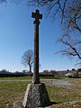 Flurkreuz
 -
 Kirche Notre-Dame de Lorette
 -
 Die Sedelle bei La Chapelle-Balou


Bevölkerungsentwicklung
| Jahr | 1962 | 1968 | 1975 | 1982 | 1990 | 1999 | 2008 | 2013 |
|---|---|---|---|---|---|---|---|---|
| Einwohner | 292 | 264 | 228 | 197 | 151 | 143 | 133 | 138 |
Weblinks
Commons: La Chapelle-Baloue – Sammlung von Bildern, Videos und Audiodateien


