Bathmen
Village in Overijssel, Netherlands

Flag
Coat of arms
52°15′0″N 6°17′13″E / 52.25000°N 6.28694°E / 52.25000; 6.28694
 Overijssel
 (2021)[1]
7437[1]
Bathmen is a village and former municipality in the east of the Netherlands. The municipality was merged with her larger neighbour of Deventer on 1 January 2005 as part of a national effort to reduce bureaucracy in the country. Its main population centres were Apenhuizen, Bathmen, Dortherhoek, Loo, Pieriksmars and Zuidloo.[3]
It was first mentioned in 1284 as Batmen. The etymology is unclear.[4] In 1840, it was home to 1,507 people. In 1997, Deventer tried to annex Bathmen, but failed.[3]
Gallery
-
 Church in Bathmen
 -
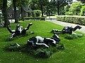 Rolling horses statue by Esther de Jong
 -
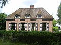 House in Bathmen
 -
 Villa Macamalo


References
- ^ a b c "Kerncijfers wijken en buurten 2021". Central Bureau of Statistics. Retrieved 18 March 2022.
- ^ "Postcodetool for 7437AA". Actueel Hoogtebestand Nederland (in Dutch). Het Waterschapshuis. Retrieved 18 March 2022.
- ^ a b "Bathmen". Plaatsengids (in Dutch). Retrieved 18 March 2022.
- ^ "Bathmen - (geografische naam)". Etymologiebank (in Dutch). Retrieved 18 March 2022.
External links
![]() Media related to Bathmen at Wikimedia Commons
Media related to Bathmen at Wikimedia Commons
- Official website
| Authority control databases |
|
|---|
- v
- t
- e


