Bukit Ho Swee
Subzone of Bukit Merah Planning Area in Central Region, Singapore
1°17′19″N 103°49′47″E / 1.28861°N 103.82972°E / 1.28861; 103.82972 Singapore
- Josephine Teo
Bukit Ho Swee (Chinese: 河水山; Pe̍h-ōe-jī: Hô-súi-soaⁿ; Jyutping: Ho4 Seoi2 Saan1) is a subzone within the planning area of Bukit Merah, Singapore, as defined by the Urban Redevelopment Authority (URA). Its boundary is made up of the Alexandra Canal in the north; Kim Seng Road and Outram Road in the east; Zion Road and Jalan Bukit Ho Swee in the south; Delta Road and Lower Delta Road in the west.[1]
Etymology
The name Bukit Ho Swee derives from both Malay and Hokkien: Bukit is Malay for hill, and Ho Swee commemorates Tay Ho Swee (鄭河水; Tēⁿ Hô-súi) (1834–1903), an influential Chinese opium and spirit farmer, timber merchant and ship owner.[2] He was also the son of Tay Han Leong, the first opium and spirit dealer in Singapore.[2] When Bukit Ho Swee got its official name in 1907, it was an area with many plank and attap houses.[2]
History
Bukit Ho Swee had a prominent Chinese community dating back to the days when Singapore was under British rule. Built over with wood frame huts with thatched roofs, it was an unplanned self-built township of about 20,000; although, like favelas everywhere, no census was ever taken. Its rabbit warren of narrow lanes, passable only to pedestrians, made it an ideal base for gangs who could escape police pursuit which was too dangerous.
A major fire, the Bukit Ho Swee Fire, broke out on 25 May 1961 and the wooden huts were completely destroyed. Unlike previous kampong fires, the inferno managed to spread across two roads, and destroying the homes of nearly 16,000 people. The scale of this fire far surmounted all previous fires. This includes the great fire of February 1959 at Kampong Tiong Bahru, which happened just across the main road from Bukit Ho Swee, a fire that rendered 5,000 people homeless. Thereafter, a second fire broke out seven years later that wiped out the remaining of Kampong Bukit Ho Swee.[3] It swept across some 200 houses and caused 3,000 people to lose their homes. The recently constituted Housing and Development Board (HDB) moved in quickly to construct low-cost housing in the form of apartment blocks. Since these were easily patrolled by the police, gang power and influence waned.
As part of the HDB's plan to move locals out of squatters into "estates", a school was opened to serve the residents. Bukit Ho Swee Secondary School opened in 1967 and was located at Lower Delta Road. In 1991 it merged with the now defunct Tiong Bahru Secondary School (est. 1966), located several minutes' walk away.[4] The site is now occupied by PSB Academy Delta campus.
Dwellings
Much of the housing in Bukit Ho Swee that existed at that time consisted of mainly one-room emergency flats and slightly bigger self-contained two room flats. A one-room rental emergency flat would cost roughly 20 dollars a month while a bigger two-room would cost only 4,000 dollar to buy.[5] Citizens often squeezed their entire families in these tiny flats – studies have shown that at one time there could be up to 10 people living in the small space. Other bigger families would resort to splitting the family between two flats.[6]
Amenities
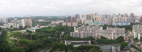
Bukit Ho Swee is now a residential estate and little remains of its chaotic past. Tiong Bahru MRT station on the East West line is the nearest MRT station from the western parts of Bukit Ho Swee while Havelock MRT station on the Thomson-East Coast line is nearer to the eastern parts of Bukit Ho Swee. Nearby schools and educational institutions include Alexandra Primary School, Zhangde Primary School, Gan Eng Seng School, Outram Secondary School and the Duke-NUS Graduate Medical School. There are two hawker centres in Bukit Ho Swee, namely Beo Crescent Market and Havelock Cooked Food Centre. There also various shops along the shophouses of Havelock road. There is a 24-hour NTUC FairPrice supermarket located in the ground level of block 50.
The entire Bukit Ho Swee town, and its neighbouring areas such as Delta Avenue estate and Indus Road is currently managed by Jalan Besar Town Council.
References
- ^ "Bukit Merah". Archived from the original on 12 May 2021. Retrieved 18 July 2018.
- ^ a b c Victor R Savage, Brenda S A Yeoh (2003), Toponymics – A Study of Singapore Street Names, Eastern Universities Press, ISBN 981-210-205-1
- ^ Khoo, P., Abul Fazil, &Yong, J. (24 November 1968). Chaos as homes go up in flames. The Straits Times, p. 1. Retrieved from NewspaperSG.
- ^ Bukit Ho Swee Secondary School (between 1961 and 1967)[permanent dead link]. NLB
- ^ Mdm Chan Yoke Yue, First Hand Account: Growing up in Bukit Ho Swee, 2016
- ^ Loh, Squatters into Citizens.
- v
- t
- e
Places in Singapore by region
Listed by planning areas (Subzones in parentheses)
- Central Area (City centre)
- Bishan
- Bukit Merah
- Alexandra Hill
- Alexandra North
- Bukit Ho Swee
- Bukit Merah
- Depot Road
- Everton Park
- HarbourFront/Maritime Square
- Henderson Hill
- Kampong Tiong Bahru
- Redhill
- Singapore General Hospital
- Telok Blangah Drive
- Telok Blangah Rise
- Telok Blangah Way
- Tiong Bahru
- Bukit Timah
- Anak Bukit
- Coronation Road
- Farrer Court
- Hillcrest
- Holland Road
- Leedon Park
- Swiss Club
- Ulu Pandan
- Downtown Core
- Anson
- Bayfront Subzone
- Bugis
- Cecil
- Central Subzone
- City Hall
- Clifford Pier
- Marina Centre
- Maxwell
- Millenia Singapore
- Nicoll
- Phillip
- Raffles Place
- Tanjong Pagar
- Geylang
- Aljunied
- Geylang East
- Kallang Way
- Kampong Ubi
- MacPherson
- Kallang
- Marina East
- Marina South
- Marine Parade
- East Coast
- Katong
- Marina East
- Marine Parade
- Mountbatten
- Museum
- Newton
- Cairnhill
- Goodwood Park
- Istana Negara
- Monk's Hill
- Newton Circus
- Orange Grove
- Novena
- Balestier
- Dunearn
- Malcolm
- Moulmein
- Mount Pleasant
- Orchard
- Boulevard
- Somerset
- Tanglin
- Outram
- China Square
- Chinatown
- Pearl's Hill
- People's Park
- Queenstown
- Commonwealth
- Dover
- Ghim Moh
- Kent Ridge
- Margaret Drive
- Mei Chin
- National University of Singapore
- one-north
- Pasir Panjang 1
- Pasir Panjang 2
- Tanglin Halt
- Queensway
- River Valley
- Institution Hill
- Leonie Hill
- One Tree Hill
- Oxley
- Paterson
- Rochor
- Bencoolen
- Farrer Park
- Kampong Glam
- Little India
- Mackenzie
- Mount Emily
- Rochor Canal
- Selegie
- Sungei Road
- Victoria
- Singapore River
- Southern Islands
- Straits View
- Tanglin
- Chatsworth
- Nassim
- Ridout
- Tyersall
- Toa Payoh
- Bidadari
- Boon Teck
- Braddell
- Joo Seng
- Kim Keat
- Lorong 8 Toa Payoh
- Pei Chun
- Potong Pasir
- Sennett
- Toa Payoh Central
- Toa Payoh West
- Woodleigh
- Bedok
- Bayshore
- Bedok North
- Reservoir
- Bedok South
- Frankel
- Kaki Bukit
- Kembangan
- Siglap
- Changi
- Airport
- Changi Point
- Changi West
- Changi Bay
- Pasir Ris
- Flora Drive
- Loyang East
- Loyang West
- Pasir Ris Central
- Pasir Ris Drive
- Pasir Ris Park
- Pasir Ris Wafer Fab Park
- Pasir Ris West
- Paya Lebar
- Airport Road, Singapore
- Paya Lebar East
- Paya Lebar North
- Paya Lebar West
- Plab
- Tampines
- Central Water Catchment
- Lim Chu Kang
- Mandai
- Mandai East
- Mandai Estate
- Mandai West
- Sembawang
- Admiralty
- Sembawang Central
- Sembawang East
- Sembawang North
- Sembawang Spring
- Sembawang Straits
- Senoko North
- Senoko South
- The Wharves
- Simpang
- Pulau Seletar
- Simpang North
- Simpang South
- Tanjong Irau
- Sungei Kadut
- Woodlands
- Greenwood Park
- Midview
- North Coast
- Senoko West
- Woodgrove
- Woodlands East
- Woodlands Regional Centre
- Woodlands South
- Woodlands West
- Yishun
- Khatib
- Lower Seletar
- Nee Soon
- Northland
- Springleaf
- Yishun Central
- Yishun East
- Yishun South
- Yishun West
- Ang Mo Kio
- Ang Mo Kio Town Centre
- Cheng San
- Chong Boon
- Kebun Baru
- Sembawang Hills
- Shangri-la
- Tagore
- Townsville, Singapore
- Yio Chu Kang
- Yio Chu Kang East
- Yio Chu Kang North
- Yio Chu Kang West
- Hougang
- Defu Industrial Park
- Hougang Central
- Hougang East
- Hougang West
- Kangkar
- Kovan
- Lorong Ah Soo
- Lorong Halus
- Tai Seng
- Trafalgar
- North-Eastern Islands
- Punggol
- Coney Island
- Matilda
- Northshore
- Punggol Canal
- Punggol Field
- Punggol Town Centre
- Waterway East
- Seletar
- Pulau Punggol Barat
- Pulau Punggol Timor
- Seletar
- Aerospace Park
- Sengkang
- Anchorvale
- Compassvale
- Fernvale
- Jalan Kayu
- Lorong Halus North
- Rivervale
- Sengkang Town Centre
- Sengkang West
- Serangoon
- Lorong Chuan
- Seletar Hills
- Serangoon Central
- Serangoon Garden
- Serangoon North
- Serangoon North Industrial Estate
- Upper Paya Lebar
- Boon Lay
- Bukit Batok
- Bukit Panjang
- Bangkit
- Dairy Farm
- Fajar
- Jelebu
- Nature Reserve
- Saujana
- Senja
- Choa Chu Kang
- Clementi
- Clementi Central
- Clementi North
- Clementi West
- Clementi Woods
- Faber
- Pandan
- Sunset Way
- Toh Tuck
- West Coast
- Jurong East
- Jurong West
- Pioneer
- Benoi Sector
- Gul Basin
- Gul Circle
- Joo Koon
- Pioneer Sector
- Tengah
- Tuas
- Tengeh
- Tuas Bay
- Tuas North
- Tuas Promenade
- Tuas View
- Tuas View Extension
- Western Islands
- Western Water Catchment


