East China
Geographical region of China
You can help expand this article with text translated from the corresponding article in Chinese. (October 2021) Click [show] for important translation instructions.
- View a machine-translated version of the Chinese article.
- Machine translation, like DeepL or Google Translate, is a useful starting point for translations, but translators must revise errors as necessary and confirm that the translation is accurate, rather than simply copy-pasting machine-translated text into the English Wikipedia.
- Do not translate text that appears unreliable or low-quality. If possible, verify the text with references provided in the foreign-language article.
- You must provide copyright attribution in the edit summary accompanying your translation by providing an interlanguage link to the source of your translation. A model attribution edit summary is
Content in this edit is translated from the existing Chinese Wikipedia article at [[:zh:华东地区]]; see its history for attribution. - You may also add the template
{{Translated|zh|华东地区}}to the talk page. - For more guidance, see Wikipedia:Translation.
Place
East China | |
|---|---|
 | |
| Country |  People's Republic of China (Mainland China) People's Republic of China (Mainland China)  Republic of China (Taiwan) Republic of China (Taiwan) |
| Area | |
| • Total | 795,837 km2 (307,274 sq mi) |
| Population | 384,364,968 |
| • Density | 483/km2 (1,250/sq mi) |
| GDP | 2022[2] |
| - Total | ¥46.291 trillion $6.883 trillion (excluding Taiwan) |
| - Per Capita | ¥120,435 $17,810 (excluding Taiwan) |
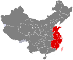
East China (华东) is a geographical region that covers the eastern coastal area of China.
A concept abolished in 1978, for economical purposes the region was defined from 1949 to 1961 by the Chinese Central Government to include the provinces of (in alphabetical order) Anhui, Fujian, Jiangsu, Shandong and Zhejiang, as well as the municipality of Shanghai. In 1961, the province of Jiangxi was added to the region (previously it was considered part of South Central China).
Since the Chinese government claims Taiwan and the few outlying islands of Fujian (Kinmen and Matsu) governed by the Republic of China (Taiwanese government) as its territory, the claimed "Taiwan Province, People's Republic of China" is also classified in this region.
Administrative divisions
| GB[3] | ISO No. 3166-2:CN[4] | Province | Chinese Name | Capital | Population (2010 census) | Density | Area | Abbreviation | |
|---|---|---|---|---|---|---|---|---|---|
| Hù | 31 | Shanghai Municipality | 上海市 Shànghǎi Shì | Shanghai | 23,019,148 | 3,630.20 | 6,341 | SH | 沪 |
| Sū | 32 | Jiangsu Province | 江苏省 Jiāngsū Shěng | Nanjing | 78,659,903 | 766.66 | 102,600 | JS | 苏 |
| Zhè | 33 | Zhejiang Province | 浙江省 Zhèjiāng Shěng | Hangzhou | 54,426,891 | 533.59 | 102,000 | ZJ | 浙 |
| Wǎn | 34 | Anhui Province | 安徽省 Ānhuī Shěng | Hefei | 59,500,510 | 425.91 | 139,700 | AH | 皖 |
| Mǐn | 35 | Fujian Province | 福建省 Fújiàn Shěng | Fuzhou | 36,894,216 | 304.15 | 121,300 | FJ | 闽 |
| Gàn | 36 | Jiangxi Province | 江西省 Jiāngxī Shěng | Nanchang | 44,567,475 | 266.87 | 167,000 | JX | 赣 |
| Lǔ | 37 | Shandong Province | 山东省 Shāndōng Shěng | Jinan | 95,793,065 | 622.84 | 153,800 | SD | 鲁 |
Cities with urban area over one million in population
Provincial capitals in bold.
| # | City | Urban area[5] | District area[5] | City proper[5] | Prov. | Census date |
|---|---|---|---|---|---|---|
| 1 | Shanghai | 20,217,748 | 22,315,474 | 23,019,196 | SH | 2010-11-01 |
| 2 | Nanjing | 5,827,888 | 7,165,292 | 8,003,744 | JS | 2010-11-01 |
| 3 | Hangzhou | 5,162,093 | 6,241,971 | 8,700,373 | ZJ | 2010-11-01 |
| 4 | Jinan | 3,527,566 | 4,335,989 | 6,813,984 | SD | 2010-11-01 |
| 5 | Qingdao | 3,519,919 | 3,718,835 | 8,715,087 | SD | 2010-11-01 |
| 6 | Suzhou | 3,302,152 | 4,072,081 | 10,459,890 | JS | 2010-11-01 |
| 7 | Xiamen | 3,119,110 | 3,531,347 | 3,531,347 | FJ | 2010-11-01 |
| 8 | Hefei | 3,098,727 | 3,310,268 | 5,702,466 | AH | 2010-11-01 |
| 9 | Fuzhou | 2,824,414 | 2,921,762 | 7,115,369 | FJ | 2010-11-01 |
| 10 | Wuxi | 2,757,736 | 3,543,719 | 6,374,399 | JS | 2010-11-01 |
| 11 | Wenzhou | 2,686,825 | 3,039,439 | 9,122,102 | ZJ | 2010-11-01 |
| 12 | Ningbo | 2,583,073 | 3,491,597 | 7,605,689 | ZJ | 2010-11-01 |
| 13 | Zibo | 2,261,717 | 3,129,228 | 4,530,597 | SD | 2010-11-01 |
| 14 | Changzhou | 2,257,376 | 3,290,918 | 4,592,431 | JS | 2010-11-01 |
| 15 | Nanchang | 2,223,661 | 2,357,839 | 5,042,566 | JX | 2010-11-01 |
| 16 | Yantai | 1,797,861 | 2,227,733 | 6,968,202 | SD | 2010-11-01 |
| 17 | Xuzhou | 1,735,166 | 1,967,214 | 8,577,225 | JS | 2010-11-01 |
| 18 | Nantong | 1,612,385 | 2,274,113 | 7,283,622 | JS | 2010-11-01 |
| 19 | Huai'an | 1,523,655 | 2,635,406 | 4,801,662 | JS | 2010-11-01 |
| 20 | Linyi | 1,522,488 | 2,303,648 | 10,039,440 | SD | 2010-11-01 |
| 21 | Weifang | 1,261,582 | 2,044,028 | 9,086,241 | SD | 2010-11-01 |
| 22 | Huainan | 1,238,488 | 1,666,826 | 2,333,896 | AH | 2010-11-01 |
| 23 | Taizhou | 1,189,276 | 1,902,510 | 5,968,838 | ZJ | 2010-11-01 |
| 24 | Jinjiang | 1,172,827 | 1,986,447 | see Quanzhou | FJ | 2010-11-01 |
| 25 | Quanzhou | 1,154,731 | 1,435,185 | 8,128,533 | FJ | 2010-11-01 |
| 26 | Yancheng | 1,136,826 | 1,615,836 | 7,262,200 | JS | 2010-11-01 |
| 27 | Tai'an | 1,123,541 | 1,735,425 | 5,494,207 | SD | 2010-11-01 |
| 28 | Kunshan | 1,118,617 | 1,644,860 | see Suzhou | JS | 2010-11-01 |
| 29 | Wuhu | 1,108,087 | 1,307,042 | 2,263,123 | AH | 2010-11-01 |
| 30 | Putian | 1,107,199 | 1,953,801 | 2,778,508 | FJ | 2010-11-01 |
| 31 | Yangzhou | 1,077,531 | 1,392,563 | 4,460,066 | JS | 2010-11-01 |
| 32 | Cixi | 1,059,942 | 1,462,383 | see Ningbo | ZJ | 2010-11-01 |
| 33 | Jiangyin | 1,013,670 | 1,595,138 | see Wuxi | JS | 2010-11-01 |
See also
 China portal

References
- ^ "Main Data of the Seventh National Population Census". National Bureau of Statistics of China. Archived from the original on May 11, 2021.
- ^ GDP-2022 is a preliminary data "Home - Regional - Quarterly by Province" (Press release). China NBS.
- ^ GB/T 2260 codes for the provinces of China
- ^ ISO 3166-2:CN (ISO 3166-2 codes for the provinces of China)
- ^ a b c 国务院人口普查办公室、国家统计局人口和社会科技统计司编 (2012). 中国2010年人口普查分县资料. Beijing: 中国统计出版社 [China Statistics Press]. ISBN 978-7-5037-6659-6.
External links
 East China travel guide from Wikivoyage
- v
- t
- e
| Overviews |
|
|---|---|
| Prehistoric | |
| Ancient | |
| Imperial |
|
| Modern |
|
| |||||||||
| Subdivisions |
| ||||||||
|---|---|---|---|---|---|---|---|---|---|
| |||
| Government | |||
|---|---|---|---|
| Military |
| ||
31°16′43″N 120°35′09″E / 31.2785°N 120.5859°E / 31.2785; 120.5859
| Authority control databases: National |
|
|---|


