National Register of Historic Places listings in Southampton County, Virginia

This is a list of the National Register of Historic Places listings in Southampton County, Virginia.
This is intended to be a complete list of the properties and districts on the National Register of Historic Places in Southampton County, Virginia, United States. The locations of National Register properties and districts for which the latitude and longitude coordinates are included below, may be seen in an online map.[1]
There are 19 properties and districts listed on the National Register in the county.
This National Park Service list is complete through NPS recent listings posted May 31, 2024.[2]
Map all coordinates using OpenStreetMap
Download coordinates as:
- KML
- GPX (all coordinates)
- GPX (primary coordinates)
- GPX (secondary coordinates)
Current listings
| [3] | Name on the Register[4] | Image | Date listed[5] | Location | City or town | Description |
|---|---|---|---|---|---|---|
| 1 | Aspen Lawn |  | April 1, 2002 (#02000319) | 4438 Hicksford Rd. 36°40′45″N 77°25′48″W / 36.679028°N 77.430000°W / 36.679028; -77.430000 (Aspen Lawn) | Drewryville | |
| 2 | Beaton-Powell House |  | November 14, 2008 (#08001058) | 32142 S. Main St. 36°35′00″N 77°12′02″W / 36.583333°N 77.200556°W / 36.583333; -77.200556 (Beaton-Powell House) | Boykins | |
| 3 | Beechwood |  | February 1, 1979 (#79003088) | Northeast of Courtland on Bethel Rd. 36°45′11″N 77°00′05″W / 36.753056°N 77.001389°W / 36.753056; -77.001389 (Beechwood) | Beales | |
| 4 | Belmont |  | October 3, 1973 (#73002061) | Northeast of Capron off Buckhorn Quarter Rd. 36°43′39″N 77°10′08″W / 36.727500°N 77.168889°W / 36.727500; -77.168889 (Belmont) | Capron | |
| 5 | Brown's Ferry |  | June 18, 1979 (#79003090) | East of Drakes Corner off Monroe Rd. 36°36′38″N 77°00′04″W / 36.610556°N 77.001111°W / 36.610556; -77.001111 (Brown's Ferry) | Drakes Corner | |
| 6 | Courtland Historic District | 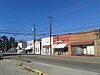 | March 19, 2020 (#100005105) | Roughly bounded by North and South Main, Rochelle, Linden, Aurora, and Bateman Sts., and Woodland Park Cir. 36°42′59″N 77°04′06″W / 36.7163°N 77.0682°W / 36.7163; -77.0682 (Courtland Historic District) | Courtland | |
| 7 | Courtland School |  | August 15, 2016 (#16000539) | 25499 Florence St. 36°43′18″N 77°04′01″W / 36.721667°N 77.067083°W / 36.721667; -77.067083 (Courtland School) | Courtland | |
| 8 | Elm Grove |  | July 24, 1979 (#79003089) | Northeast of Courtland on Governor Darden Rd. 36°44′39″N 77°01′39″W / 36.744167°N 77.027500°W / 36.744167; -77.027500 (Elm Grove) | Courtland | |
| 9 | Fortsville | 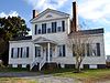 | September 15, 1970 (#70000828) | Southeast of the junction of Grizzard and Fortsville Rds. 36°42′49″N 77°25′08″W / 36.713611°N 77.418889°W / 36.713611; -77.418889 (Fortsville) | Grizzard | Straddles the border with Sussex County |
| 10 | Mahone's Tavern |  | May 29, 2008 (#08000483) | 22341 Main St. 36°42′51″N 77°04′01″W / 36.714167°N 77.066944°W / 36.714167; -77.066944 (Mahone's Tavern) | Courtland | Childhood home of Confederate General William Mahone[6] |
| 11 | Rochelle-Prince House | 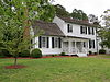 | January 7, 2011 (#10001115) | 22371 Main St. 36°42′48″N 77°04′00″W / 36.713472°N 77.066528°W / 36.713472; -77.066528 (Rochelle-Prince House) | Courtland | James Rochelle was clerk of the Southampton County court during the trial of Nat Turner. His nephew was George Henry Thomas, a Union general in the American Civil War.[6] |
| 12 | Rose Hill |  | December 31, 1979 (#79003087) | Northeast of Capron on Rose Hill Dr. 36°44′47″N 77°08′01″W / 36.746389°N 77.133611°W / 36.746389; -77.133611 (Rose Hill) | Capron | |
| 13 | Rotherwood | Upload image | September 12, 2023 (#100008835) | 15410 Southhampton Pkwy. 36°42′05″N 77°14′22″W / 36.7015°N 77.2395°W / 36.7015; -77.2395 (Rotherwood) | Capron | |
| 14 | Sebrell Rural Historic District |  | August 27, 2013 (#13000648) | Roughly bounded by the Nottoway River, the Assamoosick Swamp, and Old Hickory Rd. 36°47′07″N 77°07′34″W / 36.785278°N 77.126111°W / 36.785278; -77.126111 (Sebrell Rural Historic District) | Sebrell | |
| 15 | Simmons-Sebrell-Camp House |  | October 23, 2003 (#03001097) | 17123 Carys Bridge Rd. 36°47′21″N 77°08′03″W / 36.789167°N 77.134167°W / 36.789167; -77.134167 (Simmons-Sebrell-Camp House) | Courtland | |
| 16 | Sunnyside |  | July 8, 1982 (#82004596) | Grays Shop Rd. 36°38′37″N 77°08′36″W / 36.643611°N 77.143333°W / 36.643611; -77.143333 (Sunnyside) | Newsoms | |
| 17 | Rebecca Vaughan House |  | March 22, 2006 (#06000162) | 26315 Heritage Ln. 36°42′39″N 77°03′27″W / 36.710972°N 77.057500°W / 36.710972; -77.057500 (Rebecca Vaughan House) | Courtland | The last house in which anyone was killed during the Southampton Insurrection of 1831 |
| 18 | William H. Vincent House |  | January 16, 2004 (#03001444) | 23016 Main St. 36°42′38″N 77°12′02″W / 36.710556°N 77.200556°W / 36.710556; -77.200556 (William H. Vincent House) | Capron | |
| 19 | Millie Woodson-Turner Home Site | Upload image | April 26, 2021 (#100006436) | Approx. 570 feet (170 m) west of jct. of Indian Town and Cobb Pond Rds. Coordinates missing | Capron vicinity |
See also
Wikimedia Commons has media related to National Register of Historic Places in Southampton County, Virginia.
- List of National Historic Landmarks in Virginia
- National Register of Historic Places listings in Virginia
References
- ^ The latitude and longitude information provided in this table was derived originally from the National Register Information System, which has been found to be fairly accurate for about 99% of listings. Some locations in this table may have been corrected to current GPS standards.
- ^ National Park Service, United States Department of the Interior, "National Register of Historic Places: Weekly List Actions", retrieved May 31, 2024.
- ^ Numbers represent an alphabetical ordering by significant words. Various colorings, defined here, differentiate National Historic Landmarks and historic districts from other NRHP buildings, structures, sites or objects.
- ^ "National Register Information System". National Register of Historic Places. National Park Service. April 24, 2008.
- ^ The eight-digit number below each date is the number assigned to each location in the National Register Information System database, which can be viewed by clicking the number.
- ^ a b "Southampton County, Virginia: History". Southampton County, Virginia. Retrieved 26 April 2013.
- v
- t
- e
by county
- Accomack
- Albemarle
- Alleghany
- Amelia
- Amherst
- Appomattox
- Arlington
- Augusta
- Bath
- Bedford
- Bland
- Botetourt
- Brunswick
- Buchanan
- Buckingham
- Campbell
- Caroline
- Carroll
- Charles City
- Charlotte
- Chesterfield
- Clarke
- Craig
- Culpeper
- Cumberland
- Dickenson
- Dinwiddie
- Essex
- Fairfax
- Fauquier
- Floyd
- Fluvanna
- Franklin
- Frederick
- Giles
- Gloucester
- Goochland
- Grayson
- Greene
- Greensville
- Halifax
- Hanover
- Henrico
- Henry
- Highland
- Isle Of Wight
- James City
- King and Queen
- King George
- King William
- Lancaster
- Lee
- Loudoun
- Louisa
- Lunenburg
- Madison
- Mathews
- Mecklenburg
- Middlesex
- Montgomery
- Nelson
- New Kent
- Northampton
- Northumberland
- Nottoway
- Orange
- Page
- Patrick
- Pittsylvania
- Powhatan
- Prince Edward
- Prince George
- Prince William
- Pulaski
- Rappahannock
- Richmond
- Roanoke
- Rockbridge
- Rockingham
- Russell
- Scott
- Shenandoah
- Smyth
- Southampton
- Spotsylvania
- Stafford
- Surry
- Sussex
- Tazewell
- Warren
- Washington
- Westmoreland
- Wise
- Wythe
- York

by city
- Alexandria
- Bristol
- Buena Vista
- Charlottesville
- Chesapeake
- Colonial Heights
- Covington
- Danville
- Emporia
- Fairfax
- Falls Church
- Franklin
- Fredericksburg
- Galax
- Hampton
- Harrisonburg
- Hopewell
- Lexington
- Lynchburg
- Manassas
- Manassas Park
- Martinsville
- Newport News
- Norfolk
- Norton
- Petersburg
- Poquoson (no listings)
- Portsmouth
- Radford
- Richmond
- Roanoke
- Salem
- Staunton
- Suffolk
- Virginia Beach
- Waynesboro
- Williamsburg
- Winchester
Municipalities and communities of Southampton County, Virginia, United States | ||
|---|---|---|
County seat: Courtland | ||
| Towns |  | |
| CDPs | ||
| Unincorporated communities | ||
| ||


