Skyline-to-the-Sea Trail
Hiking trail in the Santa Cruz Mountains
| Skyline-to-the-Sea Trail | |
|---|---|
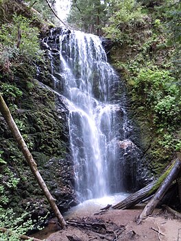 The 70 ft. (21 m) Berry Creek Falls, as seen from the wooden viewing platform | |
| Length | 29.5 mi (47.5 km) |
| Location | Santa Cruz County, California, USA |
| Trailheads | Saratoga Gap, California Waddell Beach, Pacific Ocean Castle Rock State Park California |
| Use | Hiking |
| Elevation change | 2,600 ft (790 m) |
| Highest point | Saratoga Gap, 2,600 ft (790 m) |
| Lowest point | Waddell Beach, 0 ft (0 m) |
| Difficulty | Moderate |
| Season | May 1st through November 1st |
| Sights | Castle Rock State Park Big Basin State Park |
| Hazards | Severe Weather |
The Skyline-to-the-Sea Trail is a 29.5-mile (47.2-kilometre) hiking trail that descends from the ridge of the Santa Cruz Mountains in California to the Pacific Ocean, passing through Castle Rock State Park and Big Basin Redwoods State Park. Big Basin is California's oldest state park. It contains beautiful waterfalls and some of the largest, tallest, and oldest Redwood forests left in existence.[citation needed]
After the August 2020 CZU Lightning Complex fires, the trail closed, along with much of Big Basin Redwoods State Park. As of December 2021, the trail remains closed and its future is unclear.[1][2]
The trail usually takes two to three days to complete, with nearly all thru-hikers traveling from East to West (towards the ocean). It is possible to walk the entire trail in one day, though this is unusual and very difficult. However, there is a 50-km (31-mi) ultra running race held on this trail one or two times per year. Many hikers like to take a detour up Berry Creek Trail to see the waterfalls or to camp at Sunset Trail Camp, adding 2.7 mi (4.3 km) to the hike.[citation needed]

The trail begins at Saratoga Gap on the ridge at the intersection of SR 9 and Skyline Boulevard (SR 35), although many hikers actually begin at Castle Rock due to its overnight parking facility. The trail parallels SR 9 through Castle Rock, crosses the highway, and then follows SR 236 to Big Basin park headquarters. It then descends through Big Basin, following Waddell Creek to its outlet at Waddell Beach.[citation needed]
Santa Cruz Metro routes 35 and 40 formerly went from Big Basin State Park Headquarters to Waddell Creek and back. Since September 2011, Route 40 no longer goes all the way to Waddell Beach from mid-December to mid-March.[3] but instead turns around at Cement Plant Rd. Route 35 formerly stopped at Big Basin Headquarters on the weekends during the Spring/Summer season.
As of October 2020, there is 3.6 mile (5.8 km) extension that creates a "Saratoga-to-the-Sea" Trail.[4] The trail originates at Saratoga Quarry Park, and terminates at Sanborn-Skyline County Park. This trail connects to the Skyline-to-the-Sea Trail via a completed section of the Bay Area Ridge Trail. The park is owned by the city of Saratoga's Parks Department.[5]
-
 The Skyline-to-the-Sea Trail passing through a fallen California Redwood tree.
 -
 The Skyline-to-the-Sea Trail passing over Waddell Creek.


References
External links
- Hiking Trails in Santa Cruz County - Santa Cruz Wiki
- v
- t
- e
- Black Mountain
- Crystal Peak
- Loma Prieta
- Long Ridge
- Montara Mountain
- Mount Bielawski
- Mount Chual
- Mount Madonna
- Mount Thayer
- Mount Umunhum
- San Bruno Mountain
- Santa Teresa Hills
- Twin Peaks

- Adobe Creek
- Alamitos Creek
- Alpine Creek
- Bean Creek
- Bogess Creek
- Boulder Creek
- Branciforte Creek
- Butano Creek
- Carbonera Creek
- Clear Creek
- Coyote Creek
- Deer Creek
- El Corte de Madera Creek
- Guadalupe River
- Guadalupe Valley Creek
- Hale Creek
- Harrington Creek
- La Honda Creek
- Laguna Creek
- Little Boulder Creek
- Llagas Creek
- Loch Lomond
- Los Gatos Creek
- Love Creek
- Naples Creek
- Permanente Creek
- Pescadero Creek
- Peters Creek
- Pilarcitos Creek
- San Bruno Creek
- San Francisquito Creek
- San Gregorio Creek
- San Lorenzo River
- San Pedro Creek
- San Vicente Creek
- Stevens Creek
- Tip Toe Falls
- Uvas Creek
- Waddell Creek
- Waterman Creek
- Zayante Creek
- Bay Area Ridge Trail
- Devil's Slide Trail
- Skyline-to-the-Sea Trail
- Bear Creek Redwoods
- Coal Creek
- El Corte de Madera Creek
- El Sereno
- Foothills
- Fremont Older
- La Honda Creek
- Long Ridge
- Los Trancos
- Monte Bello
- Picchetti Ranch
- Pulgas Ridge
- Purisima Creek Redwoods
- Rancho San Antonio
- Ravenswood
- Russian Ridge
- Saratoga Gap
- Sierra Azul
- Skyline Ridge
- St. Joseph's Hill
- Stevens Creek
- Teague Hill
- Thornewood
- Windy Hill
| ||
|---|---|---|
| Interstate |  | |
| Bay Area |
| |
| Sierra Nevada | ||
| Southern California |
| |
| Other | ||
37°10′32″N 122°14′12″W / 37.1755175°N 122.236644°W / 37.1755175; -122.236644


